
Garmin GPSmap 66i
GPS Handheld and Satellite Communicator
Precise navigation meets global communication in the rugged GPSMAP 66i button-operated GPS handheld and satellite communicator1 featuring Garmin TopoActive mapping and inReach® technology.
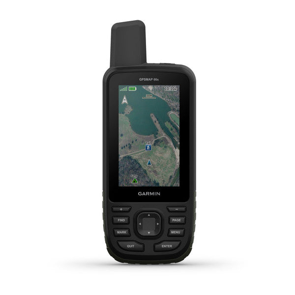
- Large, 3” sunlight-readable color display for easy viewing
- Multiple Global Navigation Satellite Systems (GNSS) support to track your travels in more challenging environments than GPS alone plus three-axis compass and barometric altimeter
- Access to BirdsEye Satellite Imagery with direct-to-device downloads and no annual subscription
- Expanded wireless connectivity supports Active Weather for up-to-date forecasts and animated weather radar and Geocaching Live for mobile syncing and updates
- Compatible with Garmin Explore™ website and app to help you manage tracks, routes and waypoints and review statistics from the field
- Up to 16 hours of battery life in GPS mode; 1 week in expedition mode lets you explore longer than ever before on a single set of AA batteries
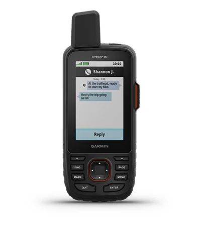
TWO-WAY MESSAGING
Exchange text messages with loved ones or friends, post to social media, or communicate from inReach to inReach in the field. Satellite subscription required.
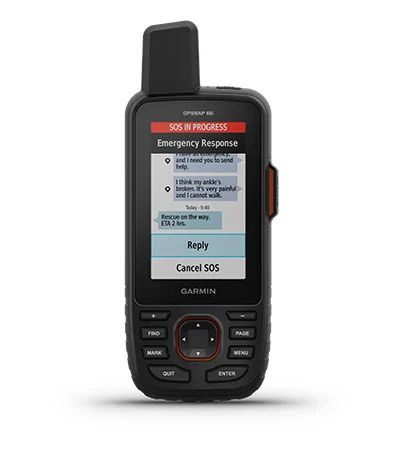
In case of emergency, trigger an interactive SOS message to GEOS, a professional 24/7 global monitoring and response centre. Satellite subscription required.
Track your location, and share it with those at home or out in the field. They’ll be able to see your progress or ping your device for your GPS location and more. Satellite subscription required.
LOCATION SHARING100% GLOBAL IRIDIUM® SATELLITE NETWORK
Instead of relying on mobile coverage, now your messages, SOS alerts and tracking are transferred via the global Iridium satellite network. Satellite subscription required.
Use inReach connectivity to get detailed weather updates on GPSMAP 66i or a compatible device paired with the Garmin Explore™ app. Request weather forecasts for your current location, waypoints or destinations on your route.
OPTIONAL INREACH WEATHERWhen paired with your compatible smartphone you can get real-time forecast information and live weather radar, so you’re always aware of the surrounding conditions.
ACTIVE WEATHERIn the Box:
- GPSMAP 66i
- Access to Birdseye Satellite Imagery
- USB cable
- Carabiner clip
- Documentation
General |
|
| Physical dimensions | 2.5" x 6.4" x 1.4" (6.2 x 16.3 x 3.5 cm) |
|---|---|
| Display size | 1.5"W x 2.5"H (3.8 x 6.3 cm); 3" diag (7.6 cm) |
| Display resolution | 240 x 400 pixels |
| Display type | transflective color TFT |
| Weight |
8.1 oz (230 g) with batteries |
| Battery | 2 AA batteries (included); NiMH or Lithium recommended |
| Water rating | IPX7 |
| Memory/History | 16 GB |
| High-sensitivity receiver | Yes |
| Interface | high-speed USB and NMEA 0183 compatible |
Maps & Memory |
|
| Preloaded maps |
basemap + TopoActive Australia |
|---|---|
| Ability to add maps | Yes |
| Basemap | Yes |
| Storage and Power Capacity | microSD™ card (not included) |
| Waypoints/favorites/locations | 10000 |
| Routes | 250 |
| Track log | 20000 points, 250 saved gpx tracks, 300 saved fit activities |
Sensors |
|
| Barometric altimeter | Yes |
|---|---|
| Compass | Yes (tilt-compensated 3-axis) |
Outdoor Recreation Features |
|
| Area calculation | Yes |
|---|---|
| Automatic routing (turn by turn routing on roads) | Yes (with optional mapping for detailed roads) |
| Geocaching-friendly | Yes (Paperless) |
| Custom maps compatible | Yes |
| Hunt/fish calendar | Yes |
| Sun and moon information | Yes |
| Picture viewer | Yes |
Garmin Connect™ |
|
| Garmin Connect™ compatible (online community where you analyze, categorize and share data) | |
|---|---|
Additional |
|
| Additional |
|
|---|---|